Welcome, guest, you can Login or Create an account
OpenCPN S-57 digitale waterkaarten Nederland OpenCPN
29,95 EUR
- Brand:
- OpenCPN
- Availability:
- In stock
- Delivery time:
- Less than one week
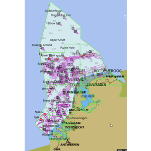
Digitale ENC/ S57 waterkaarten van Nederland OpenCPN
The official S57 charts of the Hydrographic Office.
Highly detailed water charts. Perfect for the 4tracer navigation system / OpenCPN.
Ideal for boaters, pleasure craft and commercial shipping.
These digital ENC charts maintain their detail level at any scale and can also be used in the dark.
“This product has been derived in part from material obtained from the Hydrographic Service of the Royal Netherlands Navy and UK Hydrographic Office with their permission.”
“© Copyright Hydrographic Service of the Royal Netherlands Navy (NLHS), 2023. All rights reserved.“
“NOTICE: The Hydrographic Service of the Royal Netherlands Navy and UK Hydrographic Office (NLHS and UKHO) make no warranties or representations, express or implied, with respect to this product. The NLHS and UKHO have not verified the information within this product or quality assured it.”
5/5
Henk Posted on 24 April 2023 at 12:30
Super actuele en gedetailleerde waterkaarten. Werkt top met Opencpn.
Related products
Recently viewed Clear
Information
My account
Customer service
- 4tracer (18)
- AIS (6)
- AIS Ontvanger (13)
- AIS receiver (5)
- Antenne (1)
- DComvormer (1)
- Daisy (3)
- Digitale Waterkaarten (11)
- ENC (2)
- GPS Muis (4)
- OpenCPN (24)
- OpenCPN Waterkaart (9)
- OpenCPN Waterkaarten (9)
- Oplader (1)
- Raspberry Pi (9)
- Raster Waterkaarten (6)
- Remote Wifi Hotspot (1)
- S-63 (6)
- Vectorkaart (2)
- Waterkaarten (6)
- YakBitz (2)
- beroepsvaart (1)
- gps ontvanger (2)
- gps receiver (2)
- gps usb (1)
- hydrografische (1)
- motorboot (1)
- navigatie (9)
- navigatiesysteem (1)
- opencpn.nu (6)
- openplotter (3)
- pleziervaart (1)
- quark-elec (2)
- rasterkaart (1)
- s57 (2)
- ublox (1)
- waterkaart (8)
- watersport (5)
- zeilboot (1)
- 1800 (2)
Powered by Lightspeed


